
County releases tentative maps
By Robert Cloud
Waupaca County sent its tentative redistricting map to area municipalities for input on how proposed changes will affect town board and city council districts.
Local level redistricting is necessary due to population shifts in the 2020 Census.
Due to delays in receiving the census data, all levels of municipal government have been forced to rush through the redistricting process.
The county is helping cities map new districts for their council members.
In the past, the Census Bureau delivered data by March 31 of the year following the census.
This year, counties did not receive the data until Aug. 16.
Waupaca County held a public hearing on the redistricting map on Sept. 21.
“We’re kind of under the gun right now, considering the timeline we have,” said Supervisor Pete Bosquez, who chaired the county’s redistricting committee.
The goal is for all municipalities to complete their redistricting process by the week of Oct. 18 so that the county’s redistricting committee has time to meet and consider any requested change.
The county needs to hold a public hearing and vote for final approval of the redistricting map on Nov. 9.
County Clerk Jill Lodewegen told the Waupaca County Post that time was the biggest challenge for redistricting this year.
“Everything has to be completed so that the Type A election notices for county board seats can be advertised in November,” she said. “So what typically starts with a 60-day clock once census numbers are received for county, then 60 days for municipalities to pass their wards and aldermanic districts and possibly ask for changes to the county tentative plan, and then a final 60 days for the county to finalize and pass their final supervisory district plan at a public hearing was significantly reduced.”
Lodewegen worked with Jason McKeefry, GIS coordinator and land information officer, and County Treasurer Mark Sether on the county’s redistricting.
In addition to county board districts, they help the municipalities create their wards and aldermanic districts.
“When creating wards for municipalities with 10,000 or less people, they must be between 300 and 1,000 people and cannot cross county board district lines,” Lodewegen said. “You also have to take into account that cities have aldermanic districts, which must be relatively equal. So it’s kind of like a puzzle.”
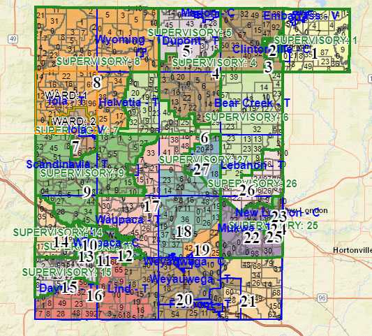
Proposed boundaries
Waupaca County has 27 county board supervisors representing a population of 51,812, according to the 2020 Census.
To be of nearly equal size, each Waupaca County supervisory districts must be as close as possible to 1,919 people.
At 1,920 people, District 5, which includes the city of Marion and most of the town of Dupont, is the closest to the ideal population with a deviation of only plus 0.05%.
Rural districts with smaller populations require larger areas.
For example, District 8, in the county’s northwest with a population of 1,827, includes the towns of Wyoming, Harrison, Iola and Helvetia and the village of Big Falls.
District 8 deviates from the 1,919 population goal by minus 2.19%.
All or parts of four supervisory districts are in the city of Waupaca.
Waupaca includes Districts 10, 11, 12 and 17.
District 10 has the largest population at 1,992, which deviates from the goal by plus 3.8%.
Royalton and Weyauwega
At the Sept. 21 hearing, Supervisor Pat Craig said one of the biggest changes occurred with Districts 18 and 19.
“District 18 is no longer all of the town of Royalton, but now goes south into Weyauwega,” Craig said. “Part of 19 includes Royalton, as well as the city of Weyauwega.”
All of the city of Weyauwega used to be in District 19.
“The advantage of this is that Royalton will now be represented by two county board supervisors, provided that both supervisors know what the issues are to the people of Royalton,” Craig said.
Jack Spierings, who is mayor of Weyauwega and a county supervisor, said the redistricting map changes the city’s aldermanic districts drastically.
One aldermanic district will have only one representative, while another district will have three representatives.
While redistricting has little effect on the county supervisory districts in the city of Clintonville, it may affect the aldermanic districts.
Each district currently has two common council members representing its residents.
Under the tentative redistricting plan, only one Clintonville alderperson will live in each of two districts, while three alderspersons will live in each of two districts.
No current county supervisors will be displaced under the tentative plan.